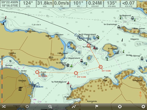
Professional marine navigation used to require an expensive GPS plotter. Now, same technology used in merchant shipping is available for the iPad.
Seapilot lets you navigate like a pro with vectorized S-57 chart data from National Maritime Administrations. Seapilot uses the iPad’s built in GPS, so it works even when there is no mobile network coverage. This is the first navigation app to feature Automatic Identification System (AIS) and AIS weather in real time, when within a mobile network. Charts available as In-App Purchase.
Use it to navigate, to plan tomorrow’s boat trip or reminisce about yesterday’s. (PS. Even works in your sofa at home.)
Seapilot for iPad features:
• Professional navigation based on merchant shipping standards for ECDIS (Electronic Chart Display and Information System)
• S-57 chart data (In-App Purchase) and AIS data from National Maritime Administrations
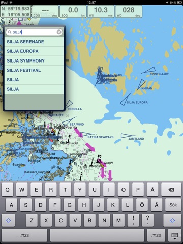
• AIS (Automatic Identification System) for real-time tracking of vessels equipped with an AIS transponder.
• Weather in real time via AIS from national weather stations showing wind speed and direction, air pressure, temperature, etc. Automatically displays information for the nearest weather station. (At present only in Sweden. To be extended.)
• High quality 5-day Coastal Weather Forecasts (In-App Purchase), directly in chart
• Developed by Stockholmradio and True Heading, leaders in marine navigation and communication at sea, with cutting-edge AIS and VHF know-how
Functions:
Δ Positioning via GPS
Δ Visualization of S-57 chart data from National Maritime Administrations
Δ AIS data from National Maritime Administrations via Internet (3G or WLAN)
Δ Course and speed vector for AIS targets
Δ AIS weather data in real time from national weather stations - SWE
Δ Autonomous navigation - charts (In-App-purchase) downloaded to the iPad
Δ Rapid chart management
Δ Easy return to own position
Δ Option of tracking your own boat on the chart
Δ Displays position, course and speed
Δ Adjustable own speed and course vector
Δ Man Overboard function
Δ Display settings for day, dawn/dusk and night
Δ Routes/waypoints (Export/Import functions in GPX-format, save to list)
Δ Past track (Export/Import in GPX-format, save to list)
Δ Plotting/marking objects (Export/Import in GPX-format, save to list)
Δ Electronic bearing and range marker from own vessel
Δ True Motion and adjustable North Up / Head Up chart orientation
Δ Chart object search
Δ AIS target search
Δ Setting of safety contour (2, 3, 6, 10 and 15 meters)
Δ Hide/show status, tool bar and own AIS target
Δ NMEA-0183 interface for connecting external GPS/AIS via WIFI
Δ High definition (HD)
Δ World chart for rough overview/orientation
Δ Facebook integration; share position with friends or all users, list friends, show friends or all users on chart, post on wall
In-App Purchase:
Δ National S-57 chart data for SWE, NOR, DEN, FIN, EST, LAT, GER, with more countries in development
Δ Swedish large scale, high detailed charts from Hydrographica
Δ Coastal Weather Forecasts for 5 days
Requirements:
iOS 5.1 or later, iPad with GPS. (External GPS unit can be used for other models.)
Based on 140 years of experience
Seapilot has been developed by True Heading (www.trueheading.se) and Stockholmradio (www.stockholmradio.se) – experts at AIS, VHF, marine navigation and communication at sea.
• True Heading is a leader in AIS products with over 40 years of navigation experience. – an authority on professional navigation.
• Stockholmradio is Sweden’s only civil coast radio station. Established over 100 years ago, Stockholmradio has unique know-how in radio communication and is a leader in VHF technology.
Contact:
Your input is essential in helping us further develop Seapilot. Feel free to contact us at info@seapilot.se. For the latest info, like Seapilot on www.facebook.com/seapilot.se
www.seapilot.com


